ads

Thursday 27 April 2017

Leaflet: Make a web map In Salesforce with Image Icon Legends with Range


Before copy and Paste below Visualforce page code and Controller code make sure you have done
below things which I have detailed explained in my Previous blog.

1) Downloaded All thee and saved them in Static Resource
     1)  Download leaflet
     2)  Download Leaflet markercluster
     3)  Download Jquery

2) Download the CSV file and Import them in Pinpint Custom object.
     1)Download Lat Long Coordinate File

3) You have made three custom label and fill the value in them which I have explained above.

 Label 1:- FeatureCollection


1
2
3
{
   "type": "FeatureCollection",
   "features": [

   Label 2:- LatlongName


 1
 2
 3
 4
 5
 6
 7
 8
 9
10
11
{
    "type": "Feature",
    "geometry": {
       "type": "Point",
       "coordinates":  [ longitude,latitude ]
    },
    "properties": {
    "LOCATION_STREET_NAME":"streetName",
    "Range":"RangeValue"
    }
  },
 
Lable 3:- last


1
2
]
}

 4) Download Below Icons and save them in Static Resource . We will use as Custom Marker Icons .
    1)  GreenLeaf
    2)  YellowLeaf
    3)  Redleaf
    4)  Rat

Now if you have done all Four points above you are ready to go .You can now Copy and Paste below visualforce page and Controller code.

Controller Code :-


 1
 2
 3
 4
 5
 6
 7
 8
 9
10
11
12
13
14
15
16
17
18
19
20
21
22
23
24
25
26
27
28
29
30
31
public class DemoLeafletClass {
    
    public list<pinpoint__c> pinList{get;set;}
    
    public String FinalStr{get;set;}
    public String HunRec{get;set;}
    
    String[] stringListmiddle = new String[0];
    
    public DemoLeafletClass (){
        
        
        pinlist = [select id,name,latitude__c,longitude__c,Pop_up__c,Range__c from pinpoint__c ];
        
        string middle ;
        
        for(pinpoint__c p:pinlist){
                        
            middle = System.Label.latlongname;
            middle = middle .replace('longitude', string.valueof(p.longitude__c));
            middle = middle .replace('latitude', String.valueof(p.latitude__c));
            middle = middle .replace('streetName', p.name);
            
            middle = middle .replace('RangeValue',string.valueof( p.range__c));            
            stringListmiddle.add(middle);            
        }
        
        FinalStr = String.join(stringListmiddle, ' ');        
        FinalStr = System.Label.FeatureCollection+FinalStr +System.Label.last;                
    }                
}

Visualforce Page:-


  1
  2
  3
  4
  5
  6
  7
  8
  9
 10
 11
 12
 13
 14
 15
 16
 17
 18
 19
 20
 21
 22
 23
 24
 25
 26
 27
 28
 29
 30
 31
 32
 33
 34
 35
 36
 37
 38
 39
 40
 41
 42
 43
 44
 45
 46
 47
 48
 49
 50
 51
 52
 53
 54
 55
 56
 57
 58
 59
 60
 61
 62
 63
 64
 65
 66
 67
 68
 69
 70
 71
 72
 73
 74
 75
 76
 77
 78
 79
 80
 81
 82
 83
 84
 85
 86
 87
 88
 89
 90
 91
 92
 93
 94
 95
 96
 97
 98
 99
100
101
102
103
104
105
106
107
108
109
110
111
112
113
114
115
116
117
118
119
120
121
122
123
124
125
126
127
128
129
130
131
132
133
134
135
136
137
138
139
140
141
142
143
144
145
146
147
148
149
150
151
152
153
154
155
156
157
158
159
160
161
162
163
164
165
166
167
168
169
170
171
172
173
174
175
176
177
178
179
180
181
182
183
184
185
186
187
188
189
190
191
192
193
194
<apex:page controller="DemoLeafletClass" >
<apex:form style="width:900px">
<apex:pageblock >
<div align="center" draggable="false" >
        <apex:commandButton value="Reload"  onclick="load();" reRender="map"  styleClass="myClass"/>    
        &nbsp;&nbsp;&nbsp;&nbsp;
        <apex:commandButton value="Clear Marker"  onclick="clearmarker();" reRender="map" styleClass="myClass" />                 
   </div>
 </apex:pageblock>
  </apex:form>

<html>
<head>
  <title>A Leaflet map!</title>
 <title>A Leaflet map!</title>
  <!---<link rel="stylesheet" href="http://cdn.leafletjs.com/leaflet-0.7.3/leaflet.css"/>-->
  <link rel="stylesheet" type="text/css" href="{!URLFOR($Resource.leaflet, '/leaflet.css')}"/>
  
  <link rel="stylesheet" type="text/css" href="{!URLFOR($Resource.MarkerCluster, 'markercluster/dist/MarkerCluster.css')}"/>
  
  <link rel="stylesheet" type="text/css" href="{!URLFOR($Resource.MarkerCluster, 'src/MarkerClusterGroup.Refresh.js')}"/>
  
  <!---<script src="http://cdn.leafletjs.com/leaflet-0.7.3/leaflet.js"></script>--->
  <script type="text/javascript" src="{!URLFOR($Resource.leaflet, '/leaflet.js')}"></script>
  
  <script type="text/javascript" src="{!URLFOR($Resource.MarkerCluster, 'markercluster/dist/leaflet.markercluster.js')}"></script>
  <link rel="stylesheet" type="text/css" href="{!URLFOR($Resource.MarkerCluster, 'markercluster/dist/MarkerCluster.Default.css')}"/>
  <!---<script src="https://code.jquery.com/jquery-2.1.1.min.js"></script>---->
    <script type="text/javascript" src="{!URLFOR($Resource.jquery, '/jquery-2.1.1.min.js')}"></script>
    <script>
    .legend {
    line-height: 18px;
    color: #555;
}
.legend i {
    width: 18px;
    height: 18px;
    float: left;
    margin-right: 8px;
    opacity: 0.7;
}
    </script>
      <style type="text/css">
.myClass{
padding: 10px;
color:white !important;
background:#00CC00 !important;

            
}
</style>

  <style>
    #map{ width: 900px; height: 600px; }
    
    .legend {
            line-height: 18px;
            color: #555;
            background: white;
            opacity:0.7;                                
        }
        .legend i {
            width: 20px;
            height: 20px;
            float: left;
            margin-right: 8px;            
            
        }
  </style>
</head>
<body>

  <div id="map"></div>

  <script>
  var rodents;

  var clusters;
  
  var markIcon = L.icon({
                    iconUrl: '{!$Resource.Greenleaf}',
                    iconSize: [25,35]
                });
                
                var markIconRed = L.icon({
                    iconUrl: '{!$Resource.redleaf}',
                    iconSize: [25,35]
                });
                
                var markIconyellow = L.icon({
                    iconUrl: '{!$Resource.yellowleaf}',
                    iconSize: [25,35]
                });


  // initialize the map
  var map = L.map('map').setView([42.35, -71.08], 13);
// load a tile layer
  L.tileLayer('http://tiles.mapc.org/basemap/{z}/{x}/{y}.png',
    {
      attribution: 'Tiles by <a href="http://mapc.org">MAPC</a>, Data by <a href="http://mass.gov/mgis">MassGIS</a>',
      maxZoom: 17,
      minZoom: 9
    }).addTo(map);
  
 function load(){  


      rodents = L.geoJson({!FinalStr} ,{
     pointToLayer: function(feature,latlng){
     
     console.log(feature.properties.Range);
     debugger;    
     
     if(feature.properties.Range == 15){
      var marker = L.marker(latlng,{icon: markIconRed });   
        }    
        
        if(feature.properties.Range == 5){
      var marker = L.marker(latlng,{icon: markIconyellow });   
        } 
        
        if(feature.properties.Range == 25){
      var marker = L.marker(latlng,{icon: markIcon });   
        }      
        
              
        marker.bindPopup(feature.properties.LOCATION_STREET_NAME+ '<br/>' + feature.geometry.type);
        return marker;
    }
  });


     clusters = L.markerClusterGroup();
       clusters.addLayer(rodents);
     var showAllPoint =  map.addLayer(clusters);
       
       map.fitBounds(showAllPoint.getBounds(), {
            padding: [50, 50]
        });
        
        
       function getColor(d) {
       //alert(d);
    return d > 1000 ? '#800026' :
           d > 500  ? '#BD0026' :
           d > 200  ? '#E31A1C' :
           d > 100  ? '#FC4E2A' :
           d > 50   ? '#FD8D3C' :
           d > 20   ? '#FEB24C' :
           d > 10   ? '#FED976' :
                      '#FFEDA0';
} 
              
var legend = L.control({position: 'bottomright'});

legend.onAdd = function (map) {

    var div = L.DomUtil.create('div', 'info legend'),
        grades = [0, 10, 20, 50],
        labels = ['{!$Resource.Greenleaf}','{!$Resource.Redleaf}','{!$Resource.Yellowleaf}','{!$Resource.rat}'];

    // loop through our density intervals and generate a label with a colored square for each interval
           for (var i = 0; i < grades.length; i++) {
        div.innerHTML +=
        grades[i] + (grades[i + 1] ? '&ndash;' + grades[i + 1] + '  ' : '+')+ (" <img src="+ labels[i] +" height='20' width='20'>") +'<br>';
    }


    return div;
};

legend.addTo(map);
   
  }
    
    function clearmarker(){    
    map.removeLayer(clusters);
    }
                     
  </script>
</body>
</html>

</apex:page>
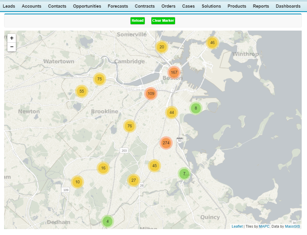
Output Screen 1:-


Leaflet: Make a web map In Salesforce with Image Icon Legends


Before copy and Paste below Visualforce page code and Controller code make sure you have done
below things which I have detailed explained in my Previous blog.

1) Downloaded All thee and saved them in Static Resource
     1)  Download leaflet
     2)  Download Leaflet markercluster
     3)  Download Jquery

2) Download the CSV file and Import them in Pinpint Custom object.
     1)Download Lat Long Coordinate File

3) You have made three custom label and fill the value in them which I have explained above.

 Label 1:- FeatureCollection


1
2
3
{
   "type": "FeatureCollection",
   "features": [

   Label 2:- LatlongName


 1
 2
 3
 4
 5
 6
 7
 8
 9
10
11
{
    "type": "Feature",
    "geometry": {
       "type": "Point",
       "coordinates":  [ longitude,latitude ]
    },
    "properties": {
    "LOCATION_STREET_NAME":"streetName",
    "Range":"RangeValue"
    }
  },
 
Lable 3:- last


1
2
]
}

 4) Download Below Icons and save them in Static Resource . We will use as Custom Marker Icons .
    1)  GreenLeaf
    2)  YellowLeaf
    3)  Redleaf
    4)  Rat

Now if you have done all Four points above you are ready to go .You can now Copy and Paste below visualforce page and Controller code.

Controller Code :-


 1
 2
 3
 4
 5
 6
 7
 8
 9
10
11
12
13
14
15
16
17
18
19
20
21
22
23
24
25
26
27
28
29
30
31
public class DemoLeafletClass {
    
    public list<pinpoint__c> pinList{get;set;}
    
    public String FinalStr{get;set;}
    public String HunRec{get;set;}
    
    String[] stringListmiddle = new String[0];
    
    public DemoLeafletClass (){
        
        
        pinlist = [select id,name,latitude__c,longitude__c,Pop_up__c,Range__c from pinpoint__c ];
        
        string middle ;
        
        for(pinpoint__c p:pinlist){
                        
            middle = System.Label.latlongname;
            middle = middle .replace('longitude', string.valueof(p.longitude__c));
            middle = middle .replace('latitude', String.valueof(p.latitude__c));
            middle = middle .replace('streetName', p.name);
            
            middle = middle .replace('RangeValue',string.valueof( p.range__c));            
            stringListmiddle.add(middle);            
        }
        
        FinalStr = String.join(stringListmiddle, ' ');        
        FinalStr = System.Label.FeatureCollection+FinalStr +System.Label.last;                
    }                
}

Visualforce Page:-


  1
  2
  3
  4
  5
  6
  7
  8
  9
 10
 11
 12
 13
 14
 15
 16
 17
 18
 19
 20
 21
 22
 23
 24
 25
 26
 27
 28
 29
 30
 31
 32
 33
 34
 35
 36
 37
 38
 39
 40
 41
 42
 43
 44
 45
 46
 47
 48
 49
 50
 51
 52
 53
 54
 55
 56
 57
 58
 59
 60
 61
 62
 63
 64
 65
 66
 67
 68
 69
 70
 71
 72
 73
 74
 75
 76
 77
 78
 79
 80
 81
 82
 83
 84
 85
 86
 87
 88
 89
 90
 91
 92
 93
 94
 95
 96
 97
 98
 99
100
101
102
103
104
105
106
107
108
109
110
111
112
113
114
115
116
117
118
119
120
121
122
123
124
125
126
127
128
129
130
131
132
133
134
135
136
137
138
139
140
141
142
143
144
145
146
147
148
149
150
151
152
153
154
155
156
157
158
159
160
161
162
163
164
165
166
167
168
169
170
171
172
173
174
175
176
177
178
179
180
181
182
183
184
185
186
187
188
189
190
191
192
193
194
195
196
197
198
199
200
201
202
203
204
205
206
207
208
209
210
211
212
213
214
215
216
<apex:page controller="DemoLeafletClass" >
<apex:form style="width:900px">
<apex:pageblock >
<div align="center" draggable="false" >
        <apex:commandButton value="Reload"  onclick="load();" reRender="map"  styleClass="myClass"/>    
        &nbsp;&nbsp;&nbsp;&nbsp;
        <apex:commandButton value="Clear Marker"  onclick="clearmarker();" reRender="map" styleClass="myClass" />                 
   </div>
 </apex:pageblock>
  </apex:form>

<html>
<head>
  <title>A Leaflet map!</title>
 <title>A Leaflet map!</title>
  <!---<link rel="stylesheet" href="http://cdn.leafletjs.com/leaflet-0.7.3/leaflet.css"/>-->
  <link rel="stylesheet" type="text/css" href="{!URLFOR($Resource.leaflet, '/leaflet.css')}"/>
  
  <link rel="stylesheet" type="text/css" href="{!URLFOR($Resource.MarkerCluster, 'markercluster/dist/MarkerCluster.css')}"/>
  
  <link rel="stylesheet" type="text/css" href="{!URLFOR($Resource.MarkerCluster, 'src/MarkerClusterGroup.Refresh.js')}"/>
  
  <!---<script src="http://cdn.leafletjs.com/leaflet-0.7.3/leaflet.js"></script>--->
  <script type="text/javascript" src="{!URLFOR($Resource.leaflet, '/leaflet.js')}"></script>
  
  <script type="text/javascript" src="{!URLFOR($Resource.MarkerCluster, 'markercluster/dist/leaflet.markercluster.js')}"></script>
  <link rel="stylesheet" type="text/css" href="{!URLFOR($Resource.MarkerCluster, 'markercluster/dist/MarkerCluster.Default.css')}"/>
  <!---<script src="https://code.jquery.com/jquery-2.1.1.min.js"></script>---->
    <script type="text/javascript" src="{!URLFOR($Resource.jquery, '/jquery-2.1.1.min.js')}"></script>
    <script>
    .legend {
    line-height: 18px;
    color: #555;
}
.legend i {
    width: 18px;
    height: 18px;
    float: left;
    margin-right: 8px;
    opacity: 0.7;
}
    </script>
      <style type="text/css">
.myClass{
padding: 10px;
color:white !important;
background:#00CC00 !important;

            
}
</style>

  <style>
    #map{ width: 900px; height: 600px; }
    
    .legend {
            line-height: 18px;
            color: #555;
            background: white;
            opacity:0.7;                                
        }
        .legend i {
            width: 20px;
            height: 20px;
            float: left;
            margin-right: 8px;            
            
        }
  </style>
</head>
<body>

  <div id="map"></div>

  <script>
  var rodents;

  var clusters;
  
  var markIcon = L.icon({
                    iconUrl: '{!$Resource.Greenleaf}',
                    iconSize: [25,35]
                });
                
                var markIconRed = L.icon({
                    iconUrl: '{!$Resource.redleaf}',
                    iconSize: [25,35]
                });
                
                var markIconyellow = L.icon({
                    iconUrl: '{!$Resource.yellowleaf}',
                    iconSize: [25,35]
                });


  // initialize the map
  var map = L.map('map').setView([42.35, -71.08], 13);
// load a tile layer
  L.tileLayer('http://tiles.mapc.org/basemap/{z}/{x}/{y}.png',
    {
      attribution: 'Tiles by <a href="http://mapc.org">MAPC</a>, Data by <a href="http://mass.gov/mgis">MassGIS</a>',
      maxZoom: 17,
      minZoom: 9
    }).addTo(map);
  
 function load(){  


      rodents = L.geoJson({!FinalStr} ,{
     pointToLayer: function(feature,latlng){
     
     console.log(feature.properties.Range);
     debugger;    
     
     if(feature.properties.Range == 15){
      var marker = L.marker(latlng,{icon: markIconRed });   
        }    
        
        if(feature.properties.Range == 5){
      var marker = L.marker(latlng,{icon: markIconyellow });   
        } 
        
        if(feature.properties.Range == 25){
      var marker = L.marker(latlng,{icon: markIcon });   
        }      
        
              
        marker.bindPopup(feature.properties.LOCATION_STREET_NAME+ '<br/>' + feature.geometry.type);
        return marker;
    }
  });


     clusters = L.markerClusterGroup();
       clusters.addLayer(rodents);
     var showAllPoint =  map.addLayer(clusters);
       
       map.fitBounds(showAllPoint.getBounds(), {
            padding: [50, 50]
        });
        
        
       function getColor(d) {
       //alert(d);
    return d > 1000 ? '#800026' :
           d > 500  ? '#BD0026' :
           d > 200  ? '#E31A1C' :
           d > 100  ? '#FC4E2A' :
           d > 50   ? '#FD8D3C' :
           d > 20   ? '#FEB24C' :
           d > 10   ? '#FED976' :
                      '#FFEDA0';
} 
              
var legend = L.control({position: 'bottomright'});

legend.onAdd = function (map) {

    var div = L.DomUtil.create('div', 'info legend'),
        grades = [0, 10, 20, 50],
        labels = ['{!$Resource.Greenleaf}','{!$Resource.Redleaf}','{!$Resource.Yellowleaf}','{!$Resource.rat}'];

    // loop through our density intervals and generate a label with a colored square for each interval
    for (var i = 0; i < grades.length; i++) {
        div.innerHTML +=
            grades[i] + (" <img src="+ labels[i] +" height='20' width='20'>") +'<br>';
    }

    return div;
};

legend.addTo(map);
   
  }
    
    function clearmarker(){    
    map.removeLayer(clusters);
    }
    
    
    function jfunction(){
    alert('jf');
       showPinpoint();
       load100();
    }
    
    var json = "{!HunRec}";
    var records = JSON.parse(json);
    console.log(records);
    function load100(){   
            alert('xys');      
                 
    rodents = L.geoJson({!HunRec});
    console.log(rodents);    
    debugger;
     clusters = L.markerClusterGroup();
        clusters.addLayer(rodents);
        map.addLayer(clusters);
   
    }


  </script>
</body>
</html>

</apex:page>


Output Screen 1:-


Leaflet: Make a web map In Salesforce with multiple Markers icon based on Range


Before copy and Paste below Visualforce page code and Controller code make sure you have done
below things which I have detailed explained in my Previous blog.

1) Downloaded All thee and saved them in Static Resource
     1)  Download leaflet
     2)  Download Leaflet markercluster
     3)  Download Jquery

2) Download the CSV file and Import them in Pinpint Custom object.
     1)Download Lat Long Coordinate File

3) You have made three custom label and fill the value in them which I have explained above.

 Label 1:- FeatureCollection


1
2
3
{
   "type": "FeatureCollection",
   "features": [

   Label 2:- LatlongName


 1
 2
 3
 4
 5
 6
 7
 8
 9
10
11
{
    "type": "Feature",
    "geometry": {
       "type": "Point",
       "coordinates":  [ longitude,latitude ]
    },
    "properties": {
    "LOCATION_STREET_NAME":"streetName",
    "Range":"RangeValue"
    }
  },
 
Lable 3:- last


1
2
]
}

 4) Download Below Icons and save them in Static Resource . We will use as Custom Marker Icons .
    1)  GreenLeaf
    2)  YellowLeaf
    3)  Redleaf
    4)  Rat

Now if you have done all Four points above you are ready to go .You can now Copy and Paste below visualforce page and Controller code.

Controller Code:-


  1
  2
  3
  4
  5
  6
  7
  8
  9
 10
 11
 12
 13
 14
 15
 16
 17
 18
 19
 20
 21
 22
 23
 24
 25
 26
 27
 28
 29
 30
 31
 32
 33
 34
 35
 36
 37
 38
 39
 40
 41
 42
 43
 44
 45
 46
 47
 48
 49
 50
 51
 52
 53
 54
 55
 56
 57
 58
 59
 60
 61
 62
 63
 64
 65
 66
 67
 68
 69
 70
 71
 72
 73
 74
 75
 76
 77
 78
 79
 80
 81
 82
 83
 84
 85
 86
 87
 88
 89
 90
 91
 92
 93
 94
 95
 96
 97
 98
 99
100
101
102
103
104
105
106
107
108
109
110
111
112
113
114
115
<apex:page controller="DemoLeafletClass" >
<apex:form style="width:900px">
<apex:pageblock >
<div align="center" draggable="false" >
        <apex:commandButton value="Reload"  onclick="load();" reRender="map"  styleClass="myClass"/>    
        &nbsp;&nbsp;&nbsp;&nbsp;
        <apex:commandButton value="Clear Marker"  onclick="clearmarker();" reRender="map" styleClass="myClass" />                 
   </div>
 </apex:pageblock>
  </apex:form>
<html>
<head>
  <title>A Leaflet map!</title>
 <title>A Leaflet map!</title>

  <link rel="stylesheet" type="text/css" href="{!URLFOR($Resource.leaflet, '/leaflet.css')}"/>  
  <link rel="stylesheet" type="text/css" href="{!URLFOR($Resource.MarkerCluster, 'markercluster/dist/MarkerCluster.css')}"/>  
  <link rel="stylesheet" type="text/css" href="{!URLFOR($Resource.MarkerCluster, 'src/MarkerClusterGroup.Refresh.js')}"/> 
  <link rel="stylesheet" type="text/css" href="{!URLFOR($Resource.MarkerCluster, 'markercluster/dist/MarkerCluster.Default.css')}"/> 

  <script type="text/javascript" src="{!URLFOR($Resource.leaflet, '/leaflet.js')}"></script>  
  <script type="text/javascript" src="{!URLFOR($Resource.MarkerCluster, 'markercluster/dist/leaflet.markercluster.js')}"></script>  
  <script type="text/javascript" src="{!URLFOR($Resource.jquery, '/jquery-2.1.1.min.js')}"></script>
  
  <style type="text/css">
.myClass{
padding: 10px;
color:white !important;
background:#00CC00 !important;

            
}
</style>
    <style>
    #map{ width: 900px; height: 600px; }
  </style>
</head>
<body>

  <div id="map"></div>

     <script>
  var rodents;

  var clusters;
  
  var markIcon = L.icon({
                    iconUrl: '{!$Resource.Greenleaf}',
                    iconSize: [25,35]
                });
                
                var markIconRed = L.icon({
                    iconUrl: '{!$Resource.redleaf}',
                    iconSize: [25,35]
                });
                
                var markIconyellow = L.icon({
                    iconUrl: '{!$Resource.yellowleaf}',
                    iconSize: [25,35]
                });
  

  // initialize the map
  var map = L.map('map').setView([42.35, -71.08], 13);
// load a tile layer
  L.tileLayer('http://tiles.mapc.org/basemap/{z}/{x}/{y}.png',
    {
      attribution: 'Tiles by <a href="http://mapc.org">MAPC</a>, Data by <a href="http://mass.gov/mgis">MassGIS</a>',
      maxZoom: 17,
      minZoom: 9
    }).addTo(map);
  
  function load(){        
      rodents = L.geoJson({!FinalStr} ,{
     pointToLayer: function(feature,latlng){
     
     console.log(feature.properties.Range);
     debugger;    
     
     if(feature.properties.Range == 15){
      var marker = L.marker(latlng,{icon: markIconRed });   
        }    
        
        if(feature.properties.Range == 5){
      var marker = L.marker(latlng,{icon: markIconyellow });   
        } 
        
        if(feature.properties.Range == 25){
      var marker = L.marker(latlng,{icon: markIcon });   
        }      
        
              
        marker.bindPopup(feature.properties.LOCATION_STREET_NAME+ '<br/>' + feature.geometry.type);
        return marker;
    }
  });
     
     clusters = L.markerClusterGroup();
       clusters.addLayer(rodents);
     var showAllPoint =  map.addLayer(clusters);   
     
       map.fitBounds(showAllPoint.getBounds(), {
            padding: [50, 50]
        });                          
    }
    
    function clearmarker(){    
        map.removeLayer(clusters);
    }                      
  
  </script>
</body>
</html>

</apex:page>

Visualforce Page :-


  1
  2
  3
  4
  5
  6
  7
  8
  9
 10
 11
 12
 13
 14
 15
 16
 17
 18
 19
 20
 21
 22
 23
 24
 25
 26
 27
 28
 29
 30
 31
 32
 33
 34
 35
 36
 37
 38
 39
 40
 41
 42
 43
 44
 45
 46
 47
 48
 49
 50
 51
 52
 53
 54
 55
 56
 57
 58
 59
 60
 61
 62
 63
 64
 65
 66
 67
 68
 69
 70
 71
 72
 73
 74
 75
 76
 77
 78
 79
 80
 81
 82
 83
 84
 85
 86
 87
 88
 89
 90
 91
 92
 93
 94
 95
 96
 97
 98
 99
100
101
102
103
104
105
106
107
108
109
110
111
112
<apex:page controller="DemoLeafletClass" >
<apex:form style="width:900px">
<apex:pageblock >
<div align="center" draggable="false" >
        <apex:commandButton value="Reload"  onclick="load();" reRender="map"  styleClass="myClass"/>    
        &nbsp;&nbsp;&nbsp;&nbsp;
        <apex:commandButton value="Clear Marker"  onclick="clearmarker();" reRender="map" styleClass="myClass" />                 
   </div>
 </apex:pageblock>
  </apex:form>
<html>
<head>
  <title>A Leaflet map!</title>
 <title>A Leaflet map!</title>

  <link rel="stylesheet" type="text/css" href="{!URLFOR($Resource.leaflet, '/leaflet.css')}"/>  
  <link rel="stylesheet" type="text/css" href="{!URLFOR($Resource.MarkerCluster, 'markercluster/dist/MarkerCluster.css')}"/>  
  <link rel="stylesheet" type="text/css" href="{!URLFOR($Resource.MarkerCluster, 'src/MarkerClusterGroup.Refresh.js')}"/> 
  <link rel="stylesheet" type="text/css" href="{!URLFOR($Resource.MarkerCluster, 'markercluster/dist/MarkerCluster.Default.css')}"/> 

  <script type="text/javascript" src="{!URLFOR($Resource.leaflet, '/leaflet.js')}"></script>  
  <script type="text/javascript" src="{!URLFOR($Resource.MarkerCluster, 'markercluster/dist/leaflet.markercluster.js')}"></script>  
  <script type="text/javascript" src="{!URLFOR($Resource.jquery, '/jquery-2.1.1.min.js')}"></script>
  
  <style type="text/css">
.myClass{
padding: 10px;
color:white !important;
background:#00CC00 !important;

            
}
</style>
    <style>
    #map{ width: 900px; height: 600px; }
  </style>
</head>
<body>

  <div id="map"></div>

     <script>
  var rodents;

  var clusters;
  
  var markIcon = L.icon({
                    iconUrl: '{!$Resource.Greenleaf}',
                    iconSize: [25,35]
                });
                
                var markIconRed = L.icon({
                    iconUrl: '{!$Resource.redleaf}',
                    iconSize: [25,35]
                });
                
                var markIconyellow = L.icon({
                    iconUrl: '{!$Resource.yellowleaf}',
                    iconSize: [25,35]
                });
  

  // initialize the map
  var map = L.map('map').setView([42.35, -71.08], 13);
// load a tile layer
  L.tileLayer('http://tiles.mapc.org/basemap/{z}/{x}/{y}.png',
    {
      attribution: 'Tiles by <a href="http://mapc.org">MAPC</a>, Data by <a href="http://mass.gov/mgis">MassGIS</a>',
      maxZoom: 17,
      minZoom: 9
    }).addTo(map);
  
  function load(){        
      rodents = L.geoJson({!FinalStr} ,{
     pointToLayer: function(feature,latlng){
     
     console.log(feature.properties.Range);
     debugger;    
     
     if(feature.properties.Range == 15){
      var marker = L.marker(latlng,{icon: markIconRed });   
        }    
        
        if(feature.properties.Range == 5){
      var marker = L.marker(latlng,{icon: markIconyellow });   
        } 
        
        if(feature.properties.Range == 25){
      var marker = L.marker(latlng,{icon: markIcon });   
        }      
        
              
        marker.bindPopup(feature.properties.LOCATION_STREET_NAME+ '<br/>' + feature.geometry.type);
        return marker;
    }
  });
     
     clusters = L.markerClusterGroup();
       clusters.addLayer(rodents);
     var showAllPoint =  map.addLayer(clusters);   
                              
    }
    
    function clearmarker(){    
        map.removeLayer(clusters);
    }                      
  
  </script>
</body>
</html>

</apex:page>

Output Screenshot 1:-


Output Screenshot 2:-


Leaflet: Make a web map In Salesforce with multiple Markers icon based on range and Use of Fitbound


Before copy and Paste below Visualforce page code and Controller code make sure you have done
below things which I have detailed explained in my Previous blog.

1) Downloaded All thee and saved them in Static Resource
     1)  Download leaflet
     2)  Download Leaflet markercluster
     3)  Download Jquery

2) Download the CSV file and Import them in Pinpint Custom object.
     1)Download Lat Long Coordinate File

3) You have made three custom label and fill the value in them which I have explained above.

 Label 1:- FeatureCollection


1
2
3
{
   "type": "FeatureCollection",
   "features": [

   Label 2:- LatlongName


 1
 2
 3
 4
 5
 6
 7
 8
 9
10
11
{
    "type": "Feature",
    "geometry": {
       "type": "Point",
       "coordinates":  [ longitude,latitude ]
    },
    "properties": {
    "LOCATION_STREET_NAME":"streetName",
    "Range":"RangeValue"
    }
  },
 
Lable 3:- last


1
2
]
}

 4) Download Below Icons and save them in Static Resource . We will use as Custom Marker Icons .
    1)  GreenLeaf
    2)  YellowLeaf
    3)  Redleaf
    4)  Rat

Now if you have done all Four points above you are ready to go .You can now Copy and Paste below visualforce page and Controller code.

Controller Code :-

 1
 2
 3
 4
 5
 6
 7
 8
 9
10
11
12
13
14
15
16
17
18
19
20
21
22
23
24
25
26
27
28
29
30
31
public class DemoLeafletClass {
    
    public list<pinpoint__c> pinList{get;set;}
    
    public String FinalStr{get;set;}
    public String HunRec{get;set;}
    
    String[] stringListmiddle = new String[0];
    
    public DemoLeafletClass (){
        
        
        pinlist = [select id,name,latitude__c,longitude__c,Pop_up__c,Range__c from pinpoint__c ];
        
        string middle ;
        
        for(pinpoint__c p:pinlist){
                        
            middle = System.Label.latlongname;
            middle = middle .replace('longitude', string.valueof(p.longitude__c));
            middle = middle .replace('latitude', String.valueof(p.latitude__c));
            middle = middle .replace('streetName', p.name);
            
            middle = middle .replace('RangeValue',string.valueof( p.range__c));            
            stringListmiddle.add(middle);            
        }
        
        FinalStr = String.join(stringListmiddle, ' ');        
        FinalStr = System.Label.FeatureCollection+FinalStr +System.Label.last;                
    }                
}

Visualforce Page Code :-

  1
  2
  3
  4
  5
  6
  7
  8
  9
 10
 11
 12
 13
 14
 15
 16
 17
 18
 19
 20
 21
 22
 23
 24
 25
 26
 27
 28
 29
 30
 31
 32
 33
 34
 35
 36
 37
 38
 39
 40
 41
 42
 43
 44
 45
 46
 47
 48
 49
 50
 51
 52
 53
 54
 55
 56
 57
 58
 59
 60
 61
 62
 63
 64
 65
 66
 67
 68
 69
 70
 71
 72
 73
 74
 75
 76
 77
 78
 79
 80
 81
 82
 83
 84
 85
 86
 87
 88
 89
 90
 91
 92
 93
 94
 95
 96
 97
 98
 99
100
101
102
103
104
105
106
107
108
109
110
111
112
113
114
115
<apex:page controller="DemoLeafletClass" >
<apex:form style="width:900px">
<apex:pageblock >
<div align="center" draggable="false" >
        <apex:commandButton value="Reload"  onclick="load();" reRender="map"  styleClass="myClass"/>    
        &nbsp;&nbsp;&nbsp;&nbsp;
        <apex:commandButton value="Clear Marker"  onclick="clearmarker();" reRender="map" styleClass="myClass" />                 
   </div>
 </apex:pageblock>
  </apex:form>
<html>
<head>
  <title>A Leaflet map!</title>
 <title>A Leaflet map!</title>

  <link rel="stylesheet" type="text/css" href="{!URLFOR($Resource.leaflet, '/leaflet.css')}"/>  
  <link rel="stylesheet" type="text/css" href="{!URLFOR($Resource.MarkerCluster, 'markercluster/dist/MarkerCluster.css')}"/>  
  <link rel="stylesheet" type="text/css" href="{!URLFOR($Resource.MarkerCluster, 'src/MarkerClusterGroup.Refresh.js')}"/> 
  <link rel="stylesheet" type="text/css" href="{!URLFOR($Resource.MarkerCluster, 'markercluster/dist/MarkerCluster.Default.css')}"/> 

  <script type="text/javascript" src="{!URLFOR($Resource.leaflet, '/leaflet.js')}"></script>  
  <script type="text/javascript" src="{!URLFOR($Resource.MarkerCluster, 'markercluster/dist/leaflet.markercluster.js')}"></script>  
  <script type="text/javascript" src="{!URLFOR($Resource.jquery, '/jquery-2.1.1.min.js')}"></script>
  
  <style type="text/css">
.myClass{
padding: 10px;
color:white !important;
background:#00CC00 !important;

            
}
</style>
    <style>
    #map{ width: 900px; height: 600px; }
  </style>
</head>
<body>

  <div id="map"></div>

     <script>
  var rodents;

  var clusters;
  
  var markIcon = L.icon({
                    iconUrl: '{!$Resource.Greenleaf}',
                    iconSize: [25,35]
                });
                
                var markIconRed = L.icon({
                    iconUrl: '{!$Resource.redleaf}',
                    iconSize: [25,35]
                });
                
                var markIconyellow = L.icon({
                    iconUrl: '{!$Resource.yellowleaf}',
                    iconSize: [25,35]
                });
  

  // initialize the map
  var map = L.map('map').setView([42.35, -71.08], 13);
// load a tile layer
  L.tileLayer('http://tiles.mapc.org/basemap/{z}/{x}/{y}.png',
    {
      attribution: 'Tiles by <a href="http://mapc.org">MAPC</a>, Data by <a href="http://mass.gov/mgis">MassGIS</a>',
      maxZoom: 17,
      minZoom: 9
    }).addTo(map);
  
  function load(){        
      rodents = L.geoJson({!FinalStr} ,{
     pointToLayer: function(feature,latlng){
     
     console.log(feature.properties.Range);
     debugger;    
     
     if(feature.properties.Range == 15){
      var marker = L.marker(latlng,{icon: markIconRed });   
        }    
        
        if(feature.properties.Range == 5){
      var marker = L.marker(latlng,{icon: markIconyellow });   
        } 
        
        if(feature.properties.Range == 25){
      var marker = L.marker(latlng,{icon: markIcon });   
        }      
        
              
        marker.bindPopup(feature.properties.LOCATION_STREET_NAME+ '<br/>' + feature.geometry.type);
        return marker;
    }
  });
     
     clusters = L.markerClusterGroup();
       clusters.addLayer(rodents);
     var showAllPoint =  map.addLayer(clusters);   
     
       map.fitBounds(showAllPoint.getBounds(), {
            padding: [50, 50]
        });                          
    }
    
    function clearmarker(){    
        map.removeLayer(clusters);
    }                      
  
  </script>
</body>
</html>

</apex:page>

Output Screen 1 :-


Output Screen 2 :-